
Scientists say the past 50 years have unleashed storm dangers unlike anything seen before.
Remember when severe weather felt predictable and manageable? Those days are long gone. Over the past five decades, extreme weather has become more intense, more frequent, and frankly, more terrifying. What used to be rare weather events are now making headlines every season.
Scientists point to climate change as a major factor, but the bottom line is simple: storms that our grandparents might have seen once in their lifetime are now happening every few years. The patterns we grew up with have completely shifted, and Mother Nature seems angrier than ever.
1. Hurricanes now refuse to weaken when they hit land, causing devastation hundreds of miles inland.

Back in the day, hurricanes would lose steam pretty quickly once they made landfall. Not anymore. Modern hurricanes are holding onto their strength far longer, bringing catastrophic winds and flooding to areas that used to feel safe. Take Hurricane Ida in 2021 – it stayed strong all the way to New York, causing deadly flooding in subway tunnels.
Scientists believe warmer ocean temperatures are feeding these storms more energy, while climate change is slowing the jet stream that used to push storms along faster. The result? Hurricanes that park themselves over communities for days, dumping ridiculous amounts of rain and maintaining dangerous winds much farther from the coast than anyone expected.
2. Atmospheric rivers are turning into supercharged “sky rivers” that dump months of rain in days.

Think of atmospheric rivers as narrow bands of moisture in the sky – basically, rivers of water vapor that can stretch thousands of miles. When these hit mountains or get stuck in place, they dump incredible amounts of rain in short periods. California has been hammered by these systems recently, with some dropping 10-15 inches of rain in just a few days.
The scary part? They’re getting stronger and more frequent. Warmer air holds more moisture, so these atmospheric rivers are becoming supercharged weapons of mass flooding. What used to be a beneficial source of water for drought-stricken areas is now causing dangerous flooding, mudslides, and billions in damage across the West Coast.
3. Derechos create hurricane-force winds across hundreds of miles with almost no warning.
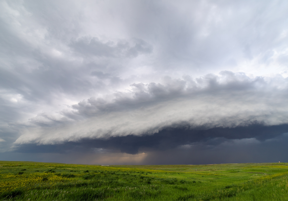
Most people had never heard the word “derecho” until recently, but these land hurricanes are becoming impossible to ignore. Picture straight-line winds of 70-100 mph racing across hundreds of miles, flattening everything in their path. The August 2020 derecho that hit Iowa was like a 400-mile-wide tornado, causing $7.5 billion in damage and leaving hundreds of thousands without power for weeks.
Unlike tornadoes that twist, derechos create sustained winds that can last for hours. They form when hot air gets trapped under cooler air, creating a bow-shaped storm system that acts like nature’s bulldozer. Climate change is making the conditions for derechos more common, and the worst part? They’re incredibly hard to predict.
4. Flash droughts are stealing crops and water supplies in a matter of weeks instead of years.

Forget everything you know about droughts being slow-moving disasters. Flash droughts can turn green farmland into dust bowls in just 4-6 weeks. The summer of 2022 was brutal – parts of Texas and Oklahoma went from normal conditions to severe drought in less than a month, catching farmers completely off guard.
Unlike traditional droughts that build over seasons, flash droughts happen when high temperatures combine with little rainfall and strong winds that suck moisture right out of the soil. Farmers are losing entire crops before they can even react. These rapid-fire droughts are becoming more common as heat waves get more intense and weather patterns become increasingly erratic.
5. Polar vortex events are bringing Arctic air to places that never see such brutal cold.
The polar vortex used to stay put in the Arctic where it belongs. Now it’s going rogue, sending Arctic air masses deep into North America and Europe. Remember February 2021 when Texas froze solid? That was the polar vortex wobbling off course, bringing temperatures 40 degrees below normal to places with no infrastructure to handle it.
The power grid failed, pipes burst, and people literally froze to death in their homes. Scientists think climate change is weakening the jet stream that normally keeps the polar vortex contained. When that boundary gets wobbly, Arctic air spills southward like water through a broken dam, causing temperature drops that can kill unprepared communities.
6. Heat domes are cooking entire regions under temperatures that shatter century-old records.
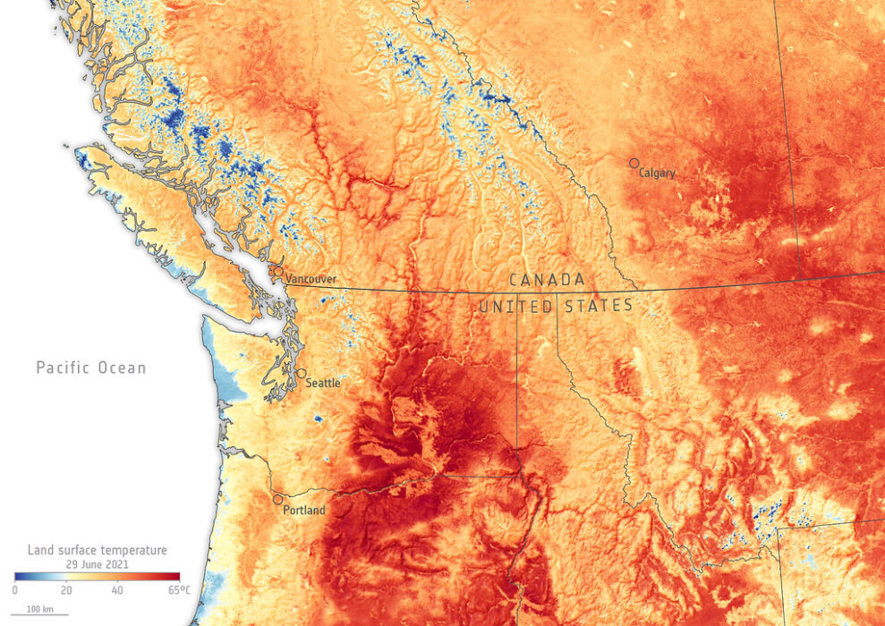
Heat domes are exactly what they sound like – massive high-pressure systems that trap hot air like a lid on a pot. The Pacific Northwest heat dome in 2021 was absolutely insane, with temperatures hitting 116°F in Portland and 121°F in British Columbia. Hundreds of people died, roads buckled, and power cables literally melted from the heat.
These aren’t your typical heat waves that move through in a few days. Heat domes can sit in place for weeks, gradually cooking everything underneath. They’re becoming more intense because climate change is making high-pressure systems stronger and more persistent. When a heat dome sets up, there’s literally nowhere for the hot air to escape.
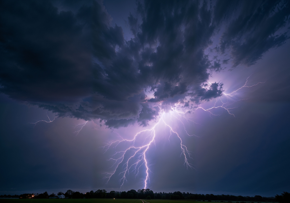
7. Bomb cyclones are exploding into monster storms that rival hurricanes in raw power.
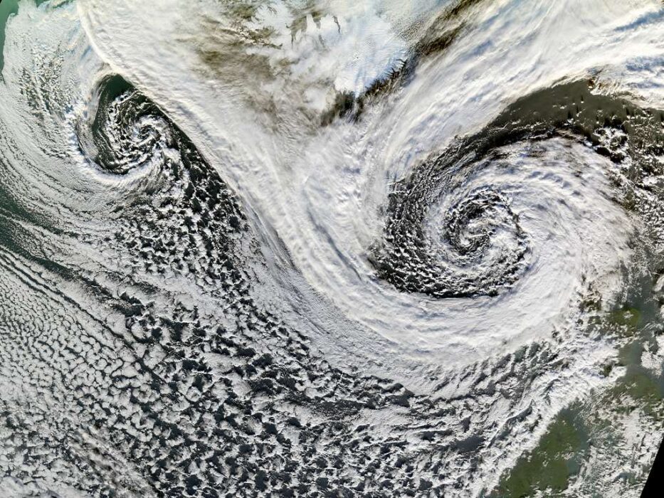
A bomb cyclone sounds made up, but it’s a real meteorological term for storms that intensify ridiculously fast – losing at least 24 millibars of pressure in 24 hours. When this happens, you get storms with hurricane-force winds, massive waves, and blizzard conditions that can shut down entire regions. It’s like watching a storm on steroids.
The East Coast has been getting hammered by these explosive storms more frequently. They form when cold Arctic air slams into warm ocean water, creating a pressure drop so rapid it’s like the storm is literally exploding. Climate change is making the temperature differences more extreme, giving bomb cyclones more fuel when they develop.
8. Tornadoes are abandoning Kansas and targeting the Southeast with deadly precision.
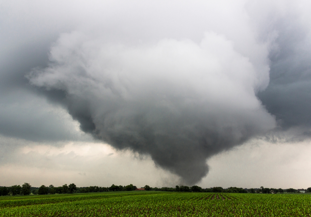
Tornado Alley is shifting east, and places like Alabama, Tennessee, and Mississippi are becoming the new hotspots for violent tornadoes. The traditional tornado corridor through Kansas and Oklahoma is actually seeing fewer storms, while the Southeast is getting slammed with more frequent and deadlier twisters. This isn’t just a temporary shift – it’s the new normal.
This geographic change is particularly dangerous because Southern tornadoes often happen at night, hit more populated areas, and encounter hills and trees that can hide them from view. The changing jet stream patterns are redirecting the atmospheric conditions that create tornadoes. Communities that never worried about tornado preparedness are now installing sirens and building storm shelters.
9. Ice storms are coating power lines in areas where freezing rain used to be rare.
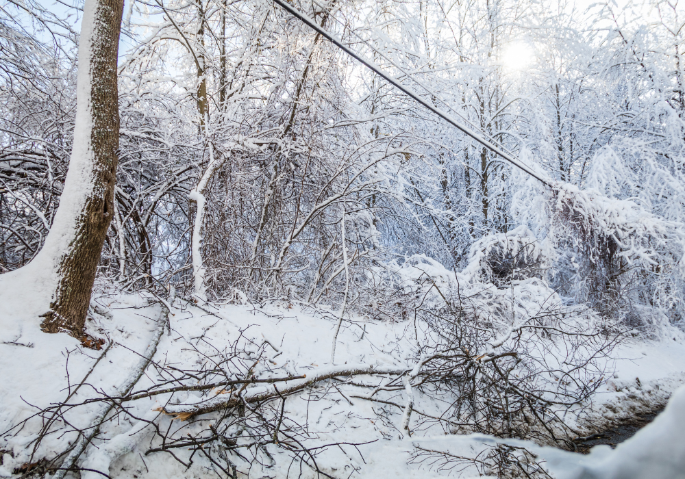
Ice storms used to be fairly predictable – you’d get them in certain regions during specific times of year. Now they’re popping up in unexpected places and creating chaos. When freezing rain coats everything in ice, power lines snap like twigs, trees fall, and entire cities can lose electricity for weeks in dangerous cold.
The 2021 ice storm that hit Texas was particularly devastating because it struck an area not equipped for extended power outages in freezing weather. These storms form when warm air overrides cold surface air, creating the perfect recipe for freezing rain. As weather patterns become more erratic, these setups are happening in places without the infrastructure to handle them.
10. Haboobs are creating massive walls of dirt that swallow entire cities whole.

Haboobs – giant dust storms that look like towering walls of dirt – used to be mostly an Arizona thing. Now they’re showing up across the Southwest with increasing frequency and intensity. These massive dust clouds can be over a mile high and 100 miles wide, turning day into night in minutes and making apocalyptic movies look tame.
Phoenix gets hit regularly, but cities like Lubbock, Texas, and even parts of Colorado are seeing more of these monsters. Drought conditions are leaving more loose soil exposed, while intense thunderstorms create the strong winds needed to lift all that dirt. When a haboob hits, visibility drops to zero, flights get canceled, and respiratory problems spike as people breathe in dust.